Witham–Maldon Branch · 1848–1964 · Essex, England
Eight miles of railway. Built by hand. Closed by memo. This project rebuilds what was lost — in precision, in permanence, and in the only medium that remains.
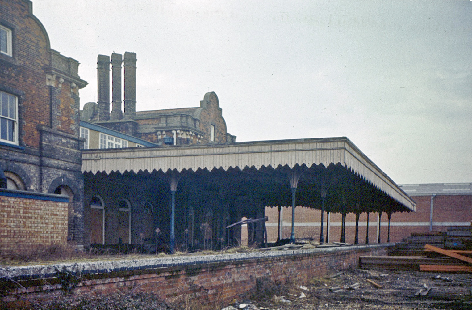
Maldon East station, 1977 — Beechwood Photography (CC BY-NC-SA 2.0)
The Permanent Way
"These permanent ways were built with human sweat, and erased with the flick of a leaky biro."
The navvies who dug the cuttings and laid the bricks of the Witham–Maldon branch in 1848 are long gone. Their work survived two world wars, the Depression, nationalisation, and six decades of gradual neglect. It did not survive Dr Beeching's report.
In 1963, a paragraph in a government document condemned the line. On 7 September 1964, the last passenger trains ran. The track was lifted. The stations fell silent. Maldon West's platforms survived into the late 1980s; its site now lies under the bypass and roundabout. Maldon East became offices.
Maldon Reborn is a digital reconstruction built from every surviving photograph, every measurable remnant, and every brick still standing. It uses a method we call hyper-photogrammetry: aggregating images across eras, angles, and resolutions to infer 3D geometry from 2D evidence. Scale anchors — a train gauge, a door height, a person in a crowd — let us measure what no surveyor ever recorded.
The result runs in BeamNG Drive. You can drive along the formation. Stand on the platform at Maldon East. Walk through the arch at Maldon West. Cross the timber viaduct over the Blackwater before it finally falls.
Station No. 1
Opened 2 October 1848 as “Maldon” · Maldon East 1889 · & Heybridge 1907 · Closed 7 September 1964 · Eastern Counties Rly / GER / LNER / BR Eastern
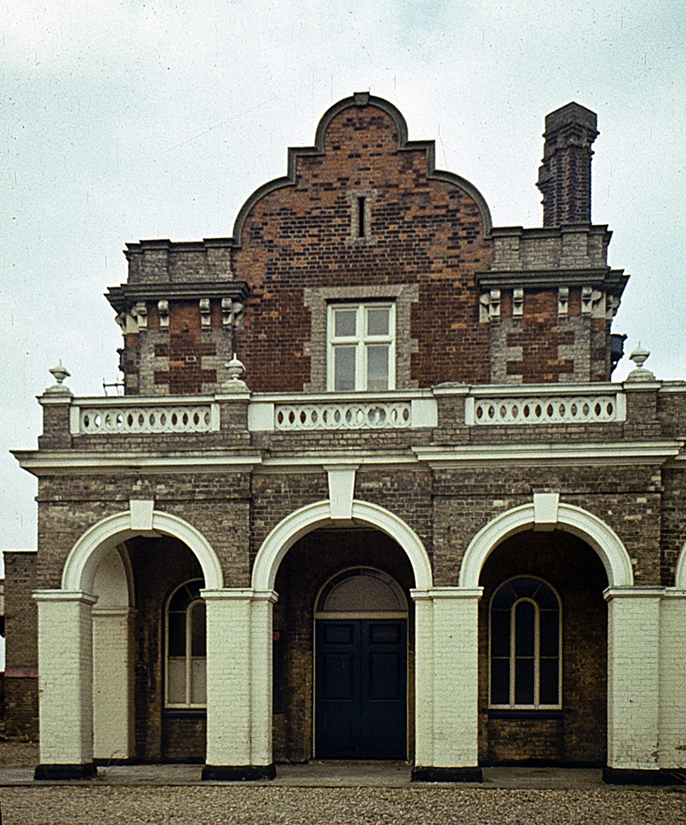
Nobody builds a branch-line terminus like this. Nine semi-circular arches across a 37-metre frontage. Curvilinear Flemish gables. Polychrome brickwork. A white balustrade. The Eastern Counties Railway gave Maldon a palace in 1848 and charged it with saying: we are modern, we matter, come and join us.
On the platform side, a long cast-iron canopy with saw-tooth valancing ran along the building and jutted out past its north-west end, towards Ulting and Witham, finishing in a hipped end. Another building abutted the south-east end, with the engine shed and Long Pond beyond. Slender columns, glass overhead, the whole thing trembling faintly when a train arrived. By 1977 it stood derelict, the platform weeds growing between the sleepers, the last train thirteen years gone. The canopy still stood. The gables still stood.
They still stand today. The building is offices now. You can drive past it. You can park in what was the forecourt. The Flemish gables look down on a car park.
| Element | Value | Conf. |
|---|---|---|
| Facade width | 35–40m | INFERRED |
| Arcade bay count | 9 semi-circular arches (counted on the 2016 photograph) | PHOTO-VERIFIED |
| Arcade height | ~5.5m | INFERRED |
| Gable peak height | 14–15m | INFERRED |
| Gable type | Curvilinear Flemish, with lunette | PHOTO-VERIFIED |
| Chimney count | 2 (inboard of each gabled block) | PHOTO-VERIFIED |
| Canopy valancing | Saw-tooth, ~250mm deep | PHOTO-VERIFIED |
| Canopy extent | From the SE gabled block to ~15m past the NW end of the building (~39m) | INFERRED (local knowledge + 1977 photo) |
| Canopy column spacing | 3.5–4m | PHOTO-VERIFIED |
| Platform height | 915mm above rail | BR STANDARD |
| Platform length | ~100m | INFERRED |
Station No. 2
Opened 1 October 1889 · Passengers closed 10 September 1939 (one source says 10 April) · Goods yard reopened 1957–59 · Great Eastern Railway
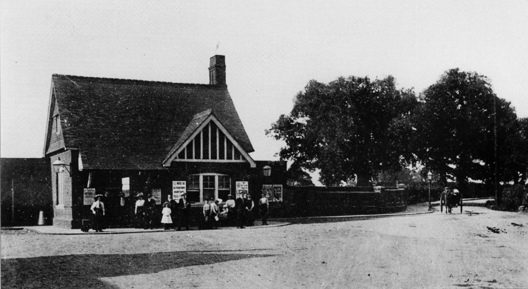
Where Maldon East announced itself to the world, Maldon West hid from it. On Wycke Hill, the booking office was a cottage: brick walls, a steep pitched gable with half-timbered facing, a chimney, a window where you bought your ticket. Entirely domestic. Entirely unremarkable from the road.
Then you walked through a door and descended. Steps down through the embankment, through a semi-circular arch of stone and brick, into a cutting that put you five metres below the road surface. The platform waited in the bottom. A train arrived from beneath the town.
The station closed to passengers in September 1939 — a wartime economy measure that was never reversed. (It had already closed once, from 1916 to 1919.) By 1960, the tracks were still in place but the booking office was falling apart. Its platforms were still there in 1978 and survived until the late 1980s. The tunnel was blocked at both ends, and the bypass roundabout now sits over the site. A red-brick goods shed and a wall along Spital Road remain.
| Element | Value | Conf. |
|---|---|---|
| Booking office width | 9–11m | INFERRED (people scale) |
| Ridge height from road | 6–7m | INFERRED (people scale) |
| Roof form | Steeply pitched gable, half-timbered face | PHOTO-VERIFIED |
| Tunnel arch form | Semi-circular | PHOTO-VERIFIED |
| Arch span | 5–6m | INFERRED (1435mm gauge) |
| Arch crown height | 5–6m from rail | INFERRED (1435mm gauge) |
| Road-to-platform drop | 4–6m | INFERRED |
| Platform length | ~65m | INFERRED (carriage count) |
The Crossing
Built 1847–48 · Timber trestle · Wickham Bishops, Essex · Scheduled Ancient Monument
The timber trestle viaduct over the River Blackwater near Wickham Bishops is one of the last surviving examples of this construction type in Eastern England. Six such structures once existed on the Witham–Maldon line. This one remains.
It is a sequence of H-frame trestle bents — pairs of vertical posts braced with diagonals, standing in the river — with heavy longitudinal stringers carrying the track. Iron bolts through hardwood. The whole thing assembled by hand in 1848 from timber that was probably old when the railway was new.
In the winter photographs from 2021, you can see where a diagonal bracing member has snapped clean through. The fracture face is still pale and fresh. The structure lists. Ivy colonises the upper deck. The river continues underneath, indifferent.
The Maldon Reborn model reconstructs the viaduct as it was in its operational prime — fresh timber, fully braced, carrying weight. Not the ruin it has become. The ruin is what was done to it. The prime is what was built.
| Element | Value | Conf. |
|---|---|---|
| Construction type | Timber trestle (H-frame bents) | PHOTO-VERIFIED |
| Total span | 30–50m | INFERRED |
| Deck height above water | 3–4.5m | PHOTO-VERIFIED |
| Bay spacing | 2.5–3.5m | PHOTO-VERIFIED |
| Main stringer section | ~300×200mm | INFERRED (eye) |
| Trestle post section | ~200×200mm | INFERRED (eye) |
| Connections | Iron bolts through timber | PHOTO-VERIFIED |
| Track type | Bull-head rail in cast iron chairs | PHOTO-VERIFIED (artefact) |
| Protection status | Scheduled Ancient Monument | CONFIRMED |
History
The Reconstruction
The Maldon Reborn map covers the full 12.9km of the Witham–Maldon branch (the 1889 Chelmer viaduct and the Maldon West link are surveyed separately) — from the junction platform at Witham to the terminus at Maldon East, with Maldon West accessible as a detour on the Woodham Ferrers alignment.
The approach to reconstruction is conservative: every dimension is rated PHOTO-VERIFIED, INFERRED, or ASSUMED. Nothing is invented. Where evidence is absent, the confidence rating says so. The goal is the highest achievable accuracy, not convenient round numbers.
| Parameter | Value | Conf. |
|---|---|---|
| Gauge | 1435mm (standard) | PHOTO-VERIFIED |
| Rail type | Bull-head in cast iron chairs | PHOTO-VERIFIED (artefact) |
| Sleeper spacing | ~630mm centres | ASSUMED (BR standard) |
| Formation width | 3–3.5m | PHOTO-VERIFIED (trail) |
| Total length | 12.9km (8 miles) | HISTORICAL RECORD |
| Max gradient | <1:100 | INFERRED (flat Essex) |
The trackbed section preserved as the Blackwater Rail Trail has developed a cathedral-like tree canopy over 60 years of growth. Mature deciduous trees arch inward from both embankment tops, forming a tunnel of green in summer and bare branches in winter. This is not incidental scenery — it is the defining atmospheric quality of the surviving formation, and it belongs in the map.
The line runs through flat Essex river-valley farmland. Textures: damp meadow grass on embankment slopes; reed beds and willow at crossings; red GER brick at every structure; flat coastal-plain sky.
Credits
This reconstruction was made possible by photographers who documented what remained before it disappeared entirely. Without their work, this project would be guesswork. Every measurement, every confidence rating, every elevation drawing traces back to someone who took a photograph.
Creative Commons images (CC BY-NC-SA 2.0) are reproduced under licence. All-rights-reserved images are used for historical analysis and dimensional inference only and are not reproduced in project outputs. All images sourced from Flickr.